Thames River Users Group 8
The River Users Groups' terms of the reference, agreed with the Environment Agency (EA), are to:
- act as a forum of communication and promote understanding between all river users
- safeguard the interests of all river users
- promote safety and goodwill
- representation from all organisations and river activities, each with one vote if decisions are needed
- up to three meetings a year
- a chairman and secretary
The RUG chairs are 'ex officio' members of the `Thames Users Navigation Forum which meets two or three times a year at the EA offices in Reading and is chaired by the EA Area Manager - West Thames.
The individual RUGs work very close with the EA's Waterways Team based at Shepperton Lock. The EA's guidance on how to:
- register a boat
- get permission to hold an event
- obtain information on river closures, restrictions can be found on the Gov.UK Boating pages and they can be contacted at: WaterwaysThames@environment-agency.gov.uk
Other RUG Areas
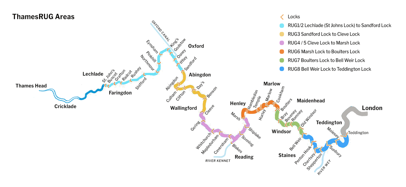
There were eight RUG groups originally, now we have:
- RUG 1 / 2 Lechlade (St Johns Lock) to Sandford Lock
- RUG3 Sandford Lock to Cleve Lock
- RUG4 / 5 Cleve Lock to Marsh Lock
- RUG6 Marsh Lock to Boulters Lock
- RUG7 Boulters Lock to Bell Weir Lock
- RUG8 Bell Weir Lock to Teddington Lock
- RUG9 Tidal Teddington Lock to the Sea
Email contact for RUGs 1 / 2 is rugs1and2@gmail.com
Email contact for RUGs 4 / 5 is andrew.wilbey@btinternet.com
Otherwise, if you wish to contact the chair of an individual RUG, please email the EA at
For an interactive map of all the locks on the non-tidal Thames and an excellent journey planner for powered and unpowered craft go to: riverthamesguide.net
Permission for Restrictions and Closures
Another important website to check regularly for warnings about strong stream conditions (yellow and red boards) is: http://riverconditions.environment-agency.gov.uk
October 2018
Friday, 19th
2018
October
Thames River Users Group 8
The River Users Groups' terms of the reference, agreed with the Environment Agency (EA), are to:
- act as a forum of communication and promote understanding between all river users
- safeguard the interests of all river users
- promote safety and goodwill
- representation from all organisations and river activities, each with one vote if decisions are needed
- up to three meetings a year
- a chairman and secretary
The RUG chairs are 'ex officio' members of the `Thames Users Navigation Forum which meets two or three times a year at the EA offices in Reading and is chaired by the EA Area Manager - West Thames.
The individual RUGs work very close with the EA's Waterways Team based at Shepperton Lock. The EA's guidance on how to:
- register a boat
- get permission to hold an event
- obtain information on river closures, restrictions can be found on the Gov.UK Boating pages and they can be contacted at: WaterwaysThames@environment-agency.gov.uk
RUG Areas
There were eight RUG groups originally, now we have:
- RUG 1 / 2 Lechlade (St Johns Lock) to Sandford Lock
- RUG3 Sandford Lock to Cleve Lock
- RUG4 / 5 Cleve Lock to Marsh Lock
- RUG6 Marsh Lock to Boulters Lock
- RUG7 Boulters Lock to Bell Weir Lock
- RUG8 Bell Weir Lock to Teddington Lock
- RUG9 Tidal Teddington Lock to the Sea
Email contact for RUGs 1 / 2 is rugs1and2@gmail.com
Email contact for RUGs 4 / 5 is andrew.wilbey@btinternet.com
Otherwise, if you wish to contact the chair of an individual RUG, please email the EA at
For an interactive map of all the locks on the non-tidal Thames and an excellent journey planner for powered and unpowered craft go to: riverthamesguide.net
Permission for Restrictions and Closures
All river restrictions and closures are posted on: https://www.gov.uk/guidance/river-thames-restrictions-and-closures and included in regular harbour master notices - email WaterwaysThames@environment-agency.gov.uk and ask to be included on the e-mailing list.
Another important website to check regularly for warnings about strong stream conditions (yellow and red boards) is: http://riverconditions.environment-agency.gov.uk
October 2018
Friday, 19th
2018
October
- ThamesRUG8 Chairman: Jonty Steel
email: - Environment Agency
Port of London Authority
London Waterways Commission
Maritime Volunteers Service (Kingston)
Maritime and Coastguard Agency
Thames Tide Tables
River Thames Guide
River Thames Navigation, Licensing and General Byelaws
The Tideway Code
River Thames Conditions - advice for boaters
River Thames Restrictions and Closures
Surrey Fire & Rescue Service